top of things

Dec 292008
 

Poas Volcano is in a cloud forest, so the last half hour or so of the drive is through dense mist.

Once at the volcano we were given the choice of a half mile walk up a fairly flat road from the Visitors’ Center to the crater, or a more interesting hike through the cloud forest to get there. Eric, Kevin and I opted for the hike, and Sarah’s wisdom lead her up the gentler path.

The three guys, having chosen the path less traveled, ended up on a pretty rigorous two mile hike at 8800 feet of altitude, with no acclimating beforehand. Not knowing that half the hike was a pretty steep and steady climb, I blasted out of the gate – regretting that strategy about half a mile later. We got a nice view of a smaller crater up higher, but the main crater was buried in a cloud when we finally arrived there.

In the meantime, Sarah had had a jolly walk to the main crater, seen it in its splendor before the clouds covered it, gave up waiting for us and strolled back to the bus.

Botos Lagoon

Botos Lagoon. This is the small crater up higher than the main one. The view lasted about 2 minutes though a hole in the clouds.

Poas Volcano Crater

Here’s what the main crater looked like: a cloud.

Pictures from our hike through the cloud forest:

Cloud Forest Fungus

Fungus

Cloud Forest Flower

Flowers. Sorry, I don’t know what type they are.

Sombrilla de Pobre

Sombrilla de Pobre, or “poor man’s umbrella,” is the common name for this Costa Rican plant – for obvious reasons.

Jan 022009
 

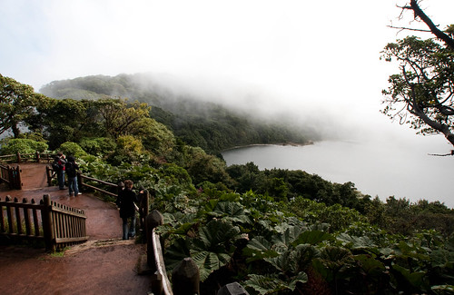
We woke up to mostly clear skies this morning, with the volcano above us sporting a cloudy cap that changed every minute. While Sarah and most of the rest of the group headed out to a boat tour near the border of Nicaragua, Eric, Kevin and I headed out to do some zip lining.

The Arenal Mundo Aventura experience was recommended to us so we had booked three reservations the day before. They picked us up at the hotel at 7:30am, and after a couple of other stops to pick up four others we headed over to their park, just a few kilometers outside Fortuna.

This was a great zip line experience, the first for all of us. After a safety introduction they loaded us into something like a bus that was towed up a dirt road by a tractor to a cable platform. We got out there, put on our harnesses and hiked up the mountain for another 15 minutes on a dense trail that was mostly stairs. That took us to the first of ten zip lines that we would ride most of the way back down the mountain.

Zipline Ready

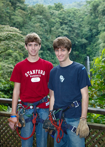
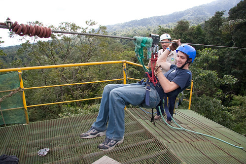
Kevin and Eric harnassed up and ready to go.

Zipline Ready

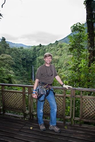
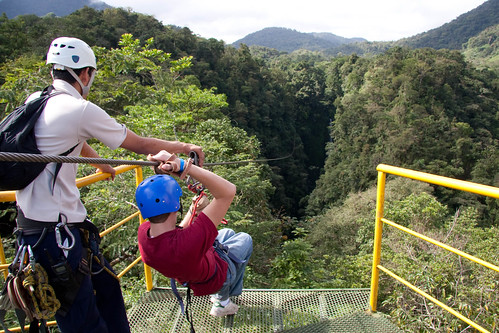
Getting psyched to zip over that waterfall.

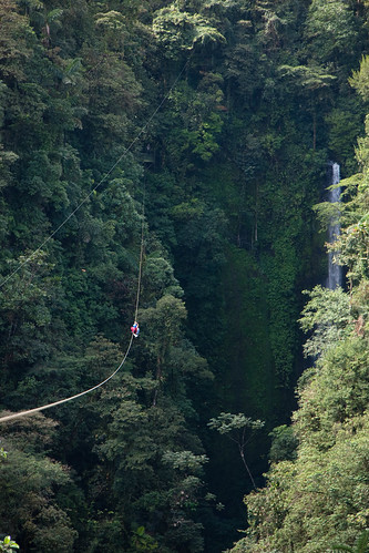
A zip line is a cable strung between two points that you ride down alone, suspended from a pulley. In our case, the cables were stretched across deep rain forest canyons cut by a river, and included the dramatic La Fortuna Waterfall that was easily 100’ tall. Some of the cables spanned canyons hundreds of feet deep.

The first three cables were fairly short, and each was faster than the prior. This was to get you comfortable with the ride, with the proper position, and with controlling your speed for a gentler stop at the end.

Go Into The Light

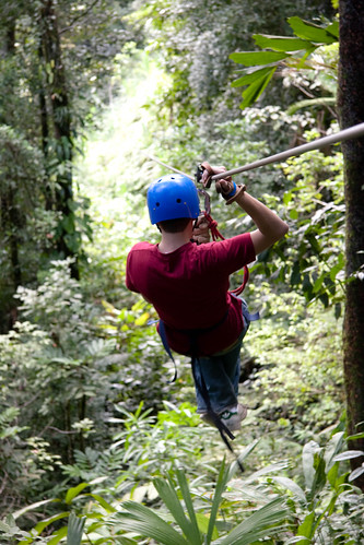
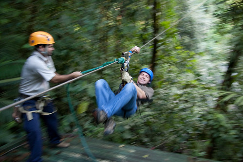
Kevin, riding into the light.

Coming Down

Viewed from the end of a cable with Eric coming down.

Gentle Landing

Eric, making a soft two point landing on one of the platforms.

Me, Landing

I came in a little faster on this one.

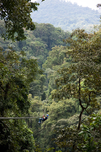
The next seven rides were much longer and faster. The longest ride was almost a kilometer, and on the fastest cable they said we traveled at about 35-40 mph. The views were incredible, at one point looking straight down at the pool below the waterfall, on another line looking out to the city of Fortuna, and on another zipping across a canyon then into a hole cut through the canopy to ride between the trees. In total we traveled about three kilometers of cable over a 45 minute period.

A Long Way To Go

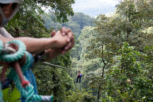
Another launch, this time on one of the longer cables. If you look and the larger version of this image (click to go to Flickr) you can just make out the landing platform next to the top of the waterfall.

Yeh, It's Way Up High

Yes, it’s a long way down.

980 Meters

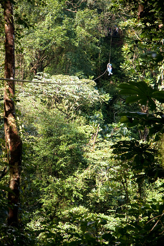
The longest cable, at 980 meters, goes over a waterfall and two canyons. That hole in the trees about 3/4s of the way up the image is the starting platform.

Hauling Himself In

If you happen to slow down along the way, you might not make it to the end. In that case you get to haul yourself in, as demonstrated here by Kevin. Notice the concern expressed by our guide (left).

As a part of the adventure, after the zip lines you visit a re-creation of an indigenous Maleku village, then ride horses back down the dirt road to the main reception area.

Maleku Village

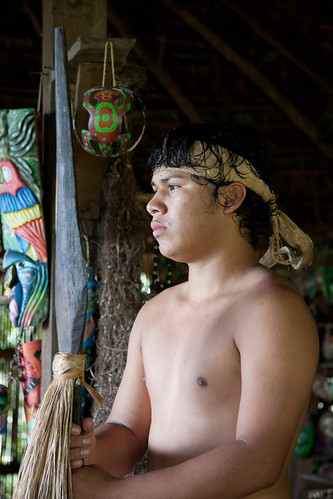
In their re-creation of an indigenous Costa Rican Maleku village, this young man told us about their lifestyle and culture.

Only one of our two guides rode down with us, and he stayed in the rear to make sure there weren’t any stragglers. The horses knew the routine so well that you didn’t have to use your reins. In fact, the herd was lead down the trail by an unsaddled black horse and no guide. A couple of times the horses would break into a trot, but otherwise it was a gentle and fun ride down. Eric’s saddle was missing the right stirrup though, so the trotting wasn’t quite so comfortable for him.

I'm Such a Cowboy

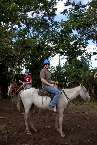
I’m such a cowboy. Even more impressive is Kevin in the background. They didn’t tell us the horses’ names, so Kevin called his ‘Rodeo’.

A Horse With No Name

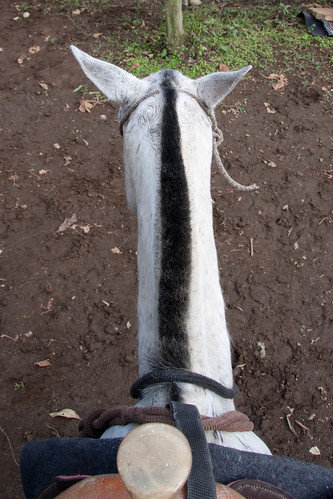
Mine: a horse with no name.

Riding Down The Mountain

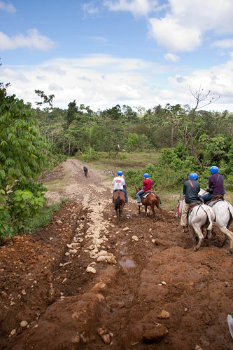
See that black horse way out front? He was our guide down the mountain.

We were taken back to the hotel, where we joined up for lunch with a few other people from our tour who had decided not to take the morning trip. After a nap and some R&R, we called a cab and headed into town to meet up with Sarah and the rest of the group.

Jun 062010
 

Day 1: Instead of napping we decided to use the ‘force your body to time shift’ approach to jet lag – after checking into our apartment we went to breakfast and started sightseeing.

Apartment on Curzon Street

Apartment on Curzon Street

Our apartment is on Curzon Street in Mayfair – it’s small, but nice and very convenient to the tube; it’s also across the street from Shepherd Market, a small area with shops and restaurants. The spot we chose for breakfast was okay, but we’re not really used to runny eggs and English style bacon and hash browns. Tomorrow we’ll try eating in, though we also found some nice pastry cafes right across the street.

Walking through Green Park

Walking through Green Park

Guard at Buckingham Palace

Guard at Buckingham Palace

Burning off the bacon, we walked through Green Park and past Buckingham Palace, then jumped the “Original Tour” double decker bus to get situated and oriented to the city, disembarking for the Tower of London, then rejoining for the rest of the loop afterwards.

Kevin and Eric atop the tour bus

Kevin and Eric atop the tour bus

The tour of the Tower of London was quite entertaining – they are hosted by Yomen of the Guard who live within the walls. We learned about many beheadings, mucky moats, how to become a Beefeater, and nuances of armor.

Beefeater, Yeoman Warder and Tourguide

Beefeater, Yeoman Warder and Tourguide

After the rest of the bus tour, including three loops through Trafalgar Square (where pigeons have been eradicated by fining humans for feeding them and sicking hawks on the birds that choose to stick around anyway), we returned home for a nap.

Late that afternoon a quick two stop ride in the tube took us back to the Thames for a ride on the London Eye. Even after 23 years of marriage I wasn’t aware of the depth of Sarah’s discomfort with heights until I asked her to take my picture near the top of the loop. Oops.

View from the top of the loop of the London Eye

View from the top of the loop of the London Eye

We had a very nice meal at an Italian restaurant near the Eye, then hopped the tube for home. Time to finally get caught up on some of that sleep!

Jun 142010
 

Our last full day in England, but it’s a very unique one. We scheduled a “Hadrian’s Wall Safari”. Hadrian’s Wall was built starting in 122 AD under Roman Emperor Hadrian. It stretched for 80 miles from the east to the west coasts of Britain, and was the northernmost border of the Roman Empire – to the north: barbarians. Our tour guide, Gary, picked us up in his Range Rover (thus the ‘safari’) around 10am.

Tour Bus

Gary's Range Rover, our tour bus for the day

There were many stops along the way, most of which started with a short hike and then a description from Gary about what we were looking at. He did a fantastic job layering the information over the course of the day so that we were building knowledge and understanding about the Roman Empire and early British history, rather than just reading about a particular site.

Hadrian's Wall

A relatively intact portion of the wall. Gary's ready to charge up the hill.

At this stop, for example, he explained why the wall was here and not further north or south. But to do so, we had to be at the top of the hill…

Charging the hill

Charging up the hill

History Lesson

Gary gives a combination history and geology lesson

It turns out there is a giant fault line here, and the minerals and other assets that an empire might want are primarily to the south. To the north the land is less valuable and not worth the cost of beating down the barbarians.

Fault lines and walls also make for great photo ops.

Photo op

Photo Op Atop the Crop

Every Roman mile (1,000 paces) along the 80 mile wall was a Mile Castle that acted as a toll gate between the Roman Empire and traders to the north. Between each Mile Castle were two towers, stationing guards every 330 paces for the width of Britain. Below is the foundation of a Mile Castle.

Mile castle

Remains of a Mile Castle

A century before Hadrian built his wall, the Romans had established forts throughout the region. Vindolanda was started around 85AD and was occupied for about 400 years. Over that time it was rebuilt on top of itself many times. There is an extensive excavation going on there now with a fantastic museum. Most significantly, they uncovered wood writing tablets that are still legible, having been protected for almost 2000 years by mud.

Vindolanda

Vindolanda excavation - the elevated floor was heated by hot water running through the channels

Crag Lough was another stop along the way. It’s close to Once Brewed, next to Twice Brewed. Twice Brewed was named for the strong ale that the Roman soldiers demanded. Once Brewed was named more recently by the founder of a youth hostel that thought that tea as a better drink to offer.

Crag Lough

Crag Lough (that's the lake in the background); Hadrian's Wall runs along the top of the ridge

There is a hiking trail that follows the wall across the country. Most of the wall is not visible now, either because it’s still buried or because the stones were recycled over the years to become smaller walls or farmhouses.

Ladder over Hadrian's Wall

A ladder for hikers to climb over the wall

Lanercost Priory was built by Henry II in the late 1100’s, mostly from stone from Hadrian’s Wall.

Lanercost Priory Door

Lanercost Priory Door

A long, educational and entertaining day!

Jump

Jump

Nov 132011
 

The first thing we learned upon arriving in Wellington is how good the coffee is. We had a bit of time to wait at the airport before Kim and Ray picked us up, so we grabbed some coffee at a shop by baggage claim. I was introduced to a ‘Flat White’, which is a Latte with a double shot of coffee in it, and it was excellent. This has become my new standard in NZ.

Kim is a friend of mine through the Visual Effects Society (VES), and is the reason I was invited to speak at AnimFX. She and Ray (both from Sauce FX) picked us up and gave us a driving tour of Weta on our way to the hotel. After hearing about Weta Digital for the first time when they were ramping up for “Lord of the Rings”, I’ve been following their work and rise to CG superpower. As is the case with so many effects and animation ‘shops,’ their humble exteriors hide the amazing work that is going on inside.

The Weta Cave

The Weta Cave - their retail shop

We checked into the Museum Hotel, right across from the Te Papa Tongarewa Museum where the conference will be happening.

View of the Te Papa Tongarewa Museum

View of the Te Papa Tongarewa Museum from our room at the Museum Hotel. The AnimFX conference is held at the Te Papa.

After lunch down the street and a walk through the Sunday farmers’ market, we boarded a bus tour of Wellington to help us get our bearings. We learned a bit about NZ politics (though it still remains somewhat cryptic to me), saw some wonderful historic architecture, drove along the Carmel-esque shoreline, and went to the top of things.

View of Wellington, NZ

Wellington, from the top of the cable car

Old St. Paul's in Wellington

Old St. Paul's, a beautiful wood church in Wellington

Sarah

Sarah, in Old St. Paul's

Me, Wellington, NZ

The view of Wellington from Mt. Victoria

We ended the day with a walk along the waterfront, stopping for drinks and a great dinner at Macs brewery.

Day 1, Winding Down

I had a Macs Wheat Beer, while Sarah dreamt of sleeping

Great Dinner

Chicken breast marinated in hard cider, with leeks, carrots and mushrooms. Yum.